Separate political control
Boundaries show where one government’s authority ends and another begins.
Unit 4 Learning Journey · Step 4
Political boundaries in AP Human Geography are lines that separate states, territories, or political units and show where one government’s authority ends and another begins.
Boundaries are not just lines on a map. They organize sovereignty, control territory, divide populations, manage resources, and sometimes create conflict. In Unit 4, political boundaries connect directly to states, territoriality, boundary disputes, devolution, and federalism.
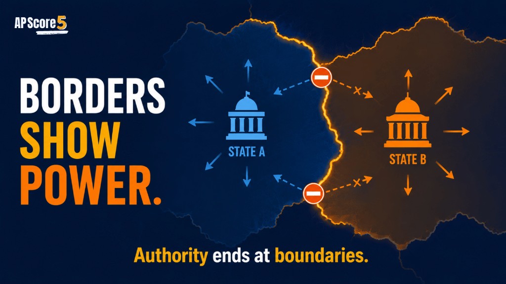
Political boundaries are lines that separate states, territories, or political units and define where political authority applies. In AP Human Geography, political boundaries help explain sovereignty, territorial control, migration rules, resource access, conflict, and cooperation between places.
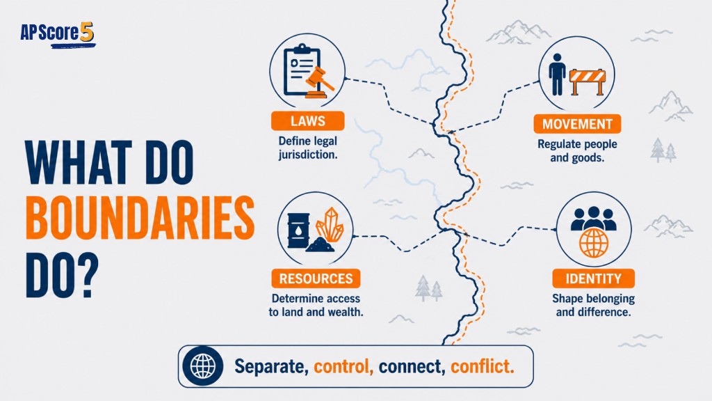
You already learned that states need sovereignty and that nations and states do not always match. Political boundaries are the lines that turn those ideas into map space. They show where a state’s authority begins, where it ends, and where conflict or cooperation may happen.
Meaning: Identity and borders do not always line up.
Meaning: Borders organize state power across space.
You are on Step 4 of the Unit 4 sequence.
Meaning: Boundaries can form before, after, or outside local settlement patterns.
Political boundaries matter because they connect power to location. A government can claim sovereignty, but boundaries show where that claim applies. Borders affect people’s citizenship, taxes, laws, voting districts, trade, migration, identity, and resource access.
Boundaries show where one government’s authority ends and another begins.
States use boundaries to define the territory they govern.
Borders can regulate immigration, trade, security, and travel.
Boundaries can decide who controls land, water, minerals, oil, or fishing zones.
Boundaries can separate or combine cultural groups.
States may dispute boundaries or cooperate across them.
Students often use these words casually, but AP Human Geography expects precise vocabulary.
| Term | Meaning | AP Clue | Example |
|---|---|---|---|
| Political boundary | Official line separating political units | Legal or mapped line | U.S.–Canada boundary |
| Border | Zone or area near a boundary | Crossing, checkpoint, security, trade | U.S.–Mexico border region |
| Frontier | Zone where state control is weak or not clearly defined | Sparse control, expansion area | Historical frontier zones |
Political boundaries usually go through four stages: definition, delimitation, demarcation, and administration. AP questions may ask about these steps directly or indirectly.
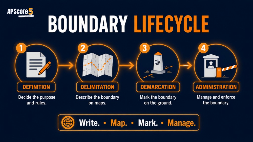
States legally describe the boundary in words.
Cartographers draw the boundary on a map.
People mark the boundary on the ground.
Governments manage the boundary through laws and policy.
| Stage | What Happens | Simple Example |
|---|---|---|
| Definition | Written legal description | Treaty says where the line should be |
| Delimitation | Boundary drawn on map | Map shows the agreed line |
| Demarcation | Boundary marked physically | Fence, wall, post, or sign |
| Administration | Boundary managed | Checkpoints, visas, customs, patrols |
Boundaries do more than divide land. They shape everyday life and political relationships.
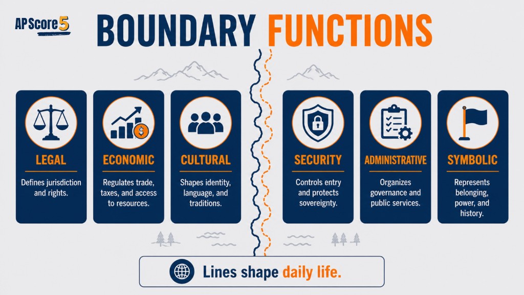
| Boundary Function | What It Does | AP Example Type |
|---|---|---|
| Legal | Separates laws and governments | Different tax or legal systems |
| Economic | Controls trade and resources | Tariffs, customs, oil, water rights |
| Cultural | Separates or combines identity groups | Language or ethnic groups across borders |
| Security | Controls movement and defense | Checkpoints, patrols, walls |
| Administrative | Organizes internal political units | Provinces, states, districts |
| Symbolic | Represents national identity | Flags, monuments, border ceremonies |
A long political boundary between two sovereign states. Parts of it are geometric, especially along the 49th parallel.
A boundary and border region shaped by migration, trade, security, and cultural interaction.
A political boundary connected to religion, partition, conflict, and disputed territory such as Kashmir.
A highly militarized boundary separating North Korea and South Korea.
Some EU member states reduce border controls through agreements, showing how supranationalism can affect boundary function.
A maritime boundary and resource dispute involving sovereignty, EEZs, trade routes, and territorial claims.
Examples can be politically complex. For AP Human Geography, focus on the boundary function: separation, control, conflict, cooperation, or resource access.
Sovereignty means a state has authority over territory. Political boundaries help define the space where that authority applies. Without boundaries, it becomes harder to know where one state’s laws, taxes, defense, resource claims, and citizenship rules begin and end.
Review sovereignty if you need a refresher on why states need recognized authority before studying border disputes.
Political boundaries can divide nations, combine different groups into one state, or reinforce national identity. This connects to nation-states, stateless nations, multinational states, and devolution.
See nation-state mismatches and devolution for how identity pressure shapes borders.
Boundaries can create conflict when states or groups disagree about where a boundary is, what it means, who controls resources, or how the boundary should be managed.
This page introduces the idea. The later Boundary Disputes guide goes deeper into definitional, locational, operational, and allocational disputes.
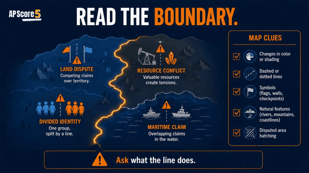
| Conflict Type | Simple Meaning | Example Clue |
|---|---|---|
| Territorial conflict | Disagreement over land | “Who owns this region?” |
| Resource conflict | Disagreement over resources | Oil, water, minerals, fish |
| Cultural conflict | Boundary divides identity group | Ethnic group split by border |
| Administrative conflict | Disagreement over border management | Checkpoints, migration, trade |
| Maritime conflict | Disagreement over ocean territory | EEZs, islands, shipping lanes |
When an AP question gives you a map, do not just look at the line. Ask what the line is doing.
Read each scenario, decide what function the boundary is performing, then tap Reveal function.
1. A line separates two sovereign countries and shows where each government’s laws apply.
Function: Separating political control / supporting sovereignty
2. A border checkpoint controls who enters a country.
Function: Controlling movement
3. A boundary splits an ethnic group across two states.
Function: Shaping identity / potential cultural conflict
4. Two countries argue over offshore oil fields.
Function: Resource conflict / maritime boundary issue
5. A treaty describes where a border should run.
Function: Definition
6. A map shows the official line between two states.
Function: Delimitation
7. A wall or fence marks the line on the ground.
Function: Demarcation
8. A border agency manages customs, visas, and patrols.
Function: Administration
| Mistake | Better AP Understanding |
|---|---|
| “Boundaries are just lines on a map” | Boundaries organize sovereignty, laws, movement, and resources |
| “Border and boundary always mean the exact same thing” | Boundary is usually the line; border often refers to the surrounding zone |
| “Every boundary causes conflict” | Some boundaries are stable and cooperative |
| “Only international boundaries matter” | Internal boundaries also shape voting, administration, and governance |
| “Physical boundaries are always fair” | Rivers and mountains can still divide people or create disputes |
| “Demarcation means drawing on a map” | Demarcation means marking the boundary on the ground |
Choices shuffle on each load. Tap an answer for instant feedback.
Which statement best defines a political boundary in AP Human Geography?
Which stage of boundary creation involves drawing the boundary on a map?
Which stage involves marking the boundary on the ground with signs, fences, walls, or posts?
A state controls immigration and trade at an official border crossing. Which boundary function is being shown?
Which concept is most directly supported by clearly defined political boundaries?
Two states disagree over offshore fishing rights and oil access. Which issue is most likely involved?
Open each card, draft your response, then reveal the rubric and sample when ready. Always connect boundaries to territory, authority, sovereignty, resources, or identity.
Tip: Outline on paper first, then type a polished version here to compare with the sample.
A. A political boundary is a line that separates states or political units and shows where one government’s authority ends and another begins.
B. Political boundaries support sovereignty by marking the territory where a state can enforce laws, collect taxes, control resources, and govern people.
C. Boundaries can create conflict when states disagree over where a line should be, who controls resources, or how migration and trade should be managed.
Status: Draft your answer first—then open the rubric or sample.
Tip: Outline on paper first, then type a polished version here to compare with the sample.
A. Delimitation is the process of drawing a political boundary on a map.
B. Demarcation is the process of physically marking a boundary on the ground with signs, fences, walls, or posts.
C. A treaty that places a line on a map is delimitation; building a fence along that line is demarcation.
D. Administration matters because states must manage customs, visas, patrols, trade rules, and legal enforcement so the boundary works in daily life.
Status: Draft your answer first—then open the rubric or sample.
Political boundaries are lines that separate states, territories, or political units and define where political authority applies.
Political boundaries are important because they organize sovereignty, laws, citizenship, movement, resource control, trade, and political conflict.
The U.S.–Canada boundary is an example of a political boundary because it separates two sovereign states and marks where each government’s authority applies.
A boundary is usually the official line separating political units. A border often refers to the area or zone around that line where movement, security, trade, and interaction happen.
The four steps are definition, delimitation, demarcation, and administration. Definition describes the boundary in words, delimitation draws it on a map, demarcation marks it on the ground, and administration manages it.
Delimitation is the process of drawing a political boundary on a map.
Demarcation is the process of physically marking a boundary on the ground using signs, fences, walls, posts, or monuments.
Political boundaries support sovereignty by identifying the territory where a state has authority to make laws, control resources, manage borders, and govern people.
Political boundaries can cause conflict when states or groups disagree over land, resources, identity, migration, border management, or maritime claims.
You now understand how boundaries turn political power into map space. Continue the Unit 4 journey with Types of Boundaries, or test yourself with Unit 4 practice questions.
You finished Step 4 of the Unit 4 sequence. Use the path below to move backward for review or forward to boundary types and the rest of the unit.
These topics connect directly to political boundaries, sovereignty, and territorial conflict.