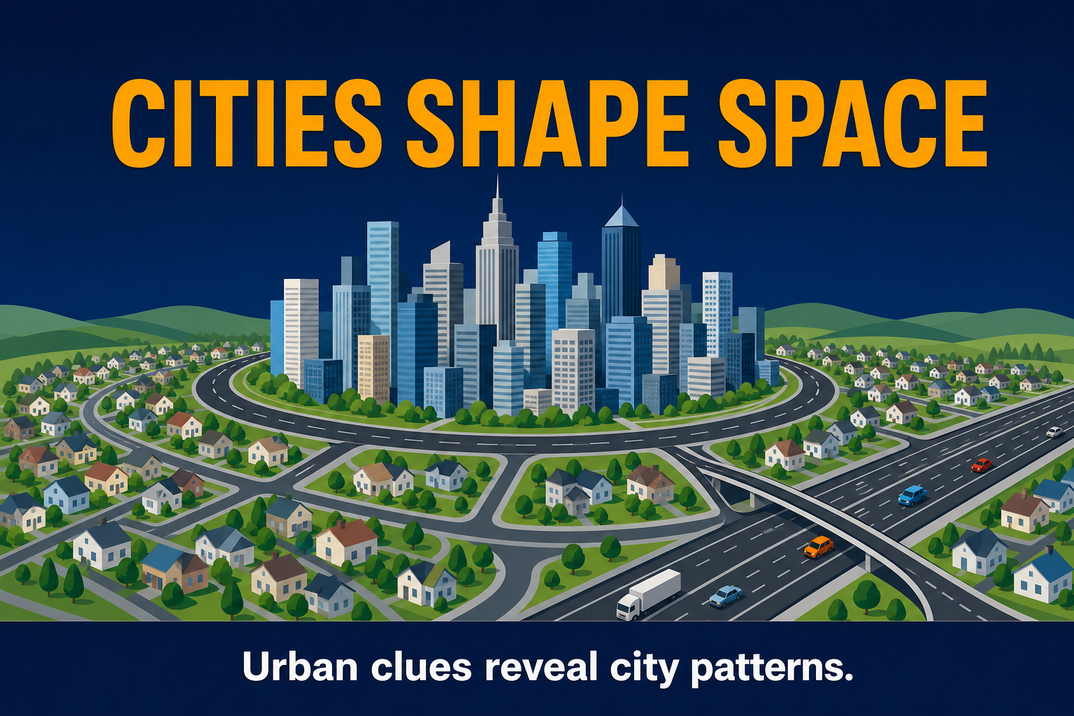
Why Cities Grow
Start with why cities form, expand, and concentrate people.
Master urbanization, city models, Central Place Theory, rank-size rule, primate cities, sprawl, gentrification, and sustainable city planning.
AP Human Geography Unit 6 studies how cities form, grow, organize land, connect to other places, and respond to urban problems. The unit focuses on urbanization, settlement hierarchy, city models, central place theory, rank-size rule, primate cities, suburbanization, sprawl, gentrification, and sustainable urban planning.
Jump to the part of Unit 6 you need most right now.
AP Human Geography Unit 6 rewards students who connect urban processes to visible spatial patterns. Before test day, you should be able to explain the following:
For spatial tools, review Unit 1 thinking geographically. Migration into cities links to Unit 2 population and migration. Neighborhood culture ties to Unit 3 cultural patterns. Capitals and governance connect to Unit 4 political patterns. Rural-to-urban land competition compares with Unit 5 agriculture and rural land use. More practice: daily practice, practice by course, practice by topic, and practice tests.
Think of Unit 6 as three questions: Why do cities exist? How are cities arranged? What problems do cities create or solve?
Follow this order so city systems, urban models, and urban change build logically.
Start with why cities form, expand, and concentrate people.
Learn how cities fit into larger settlement systems.
Master the models that explain land use inside cities.
Explain outward growth, suburbs, neighborhood change, and displacement.
Connect urban growth to planning, sustainability, and policy.
Work through all five groups, then use practice MCQs and FRQ strategy on this hub to lock in exam skills.
Urbanization → Urban Hierarchy → City Models → Suburbanization → Urban Problems → Sustainable Solutions
People and jobs concentrate in cities as rural-to-urban migration and natural increase reshape settlement.
Exam clue: Name economic pull factors, not only bigger totals.
Hamlets to world cities rank by population and service level.
Exam clue: Higher-order functions need larger market areas.
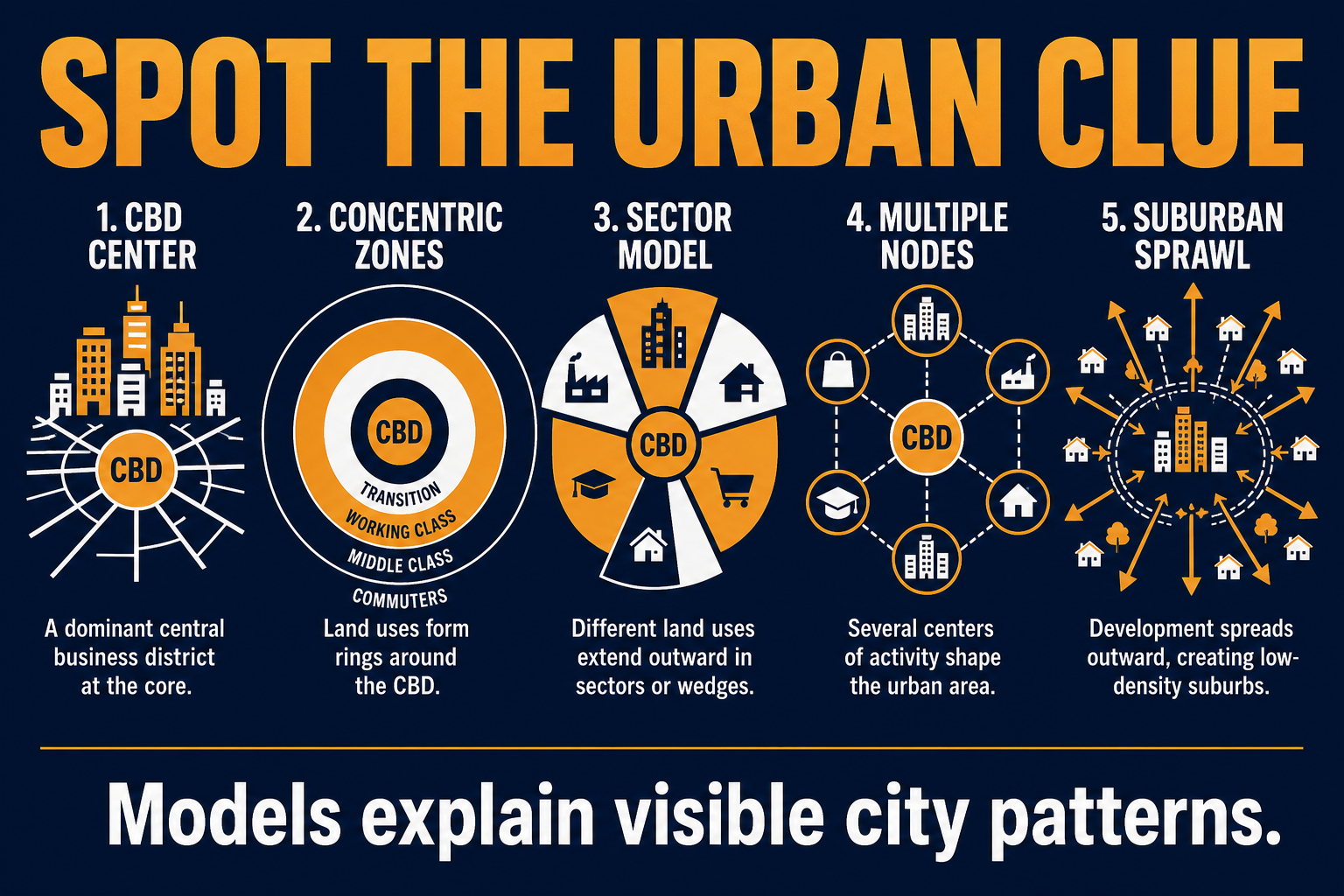
Models explain internal land-use patterns from the CBD outward.
Exam clue: Match shape on the map to the right model name.
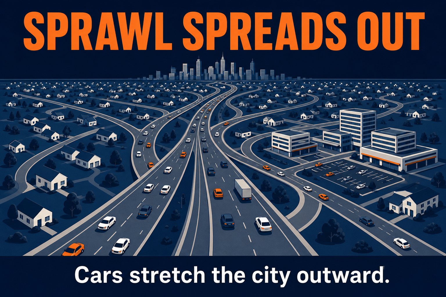
Low-density growth spreads along highways beyond the core.
Exam clue: Separated zoning plus cars stretch the city outward.
Sprawl, segregation, decay, and informal settlements create uneven burdens.
Exam clue: Pair problem with mechanism, not moral judgment alone.
Transit, density, mixed use, and growth boundaries reduce harm.
Exam clue: Smart growth targets cause and spatial outcome.
Fifteen high-yield ideas with definitions, exam clues, and common mistakes.
Growth of cities as people and jobs concentrate in urban areas.
AP exam clue: Name push (rural poverty) and pull (jobs, services) factors—not only population totals.
Common mistake: Calling all migration urbanization without rural-to-urban movement.
Site is local physical traits; situation is connections to other places.
AP exam clue: Harbor depth = site; highway junction = situation.
Common mistake: Using site and situation as synonyms.
Settlements ranked by population and service functions.
AP exam clue: Higher-order services cluster in larger centers.
Common mistake: Assuming biggest city has every function without evidence.
Christaller model of settlement spacing for goods and services.
AP exam clue: Threshold and range predict where functions locate.
Common mistake: Confusing range with threshold.
City n is often about 1/n the size of the largest city.
AP exam clue: Fourth city ≈ one-quarter of the largest in balanced systems.
Common mistake: Applying rank-size when one city dominates.
One metro far larger than the second—often 2×+.
AP exam clue: Paris or Buenos Aires style dominance on national maps.
Common mistake: Calling any capital a primate city without size data.
Global command centers for finance, law, and corporate HQ.
AP exam clue: London–New York–Tokyo style producer services.
Common mistake: Equating world city with megacity by population only.
Megacity ≈ 10M+; metacity = fused metro complexes.
AP exam clue: Lagos or Dhaka scale vs. polycentric Pearl River Delta.
Common mistake: Megacity label does not guarantee global-city functions.
Central business district—peak accessibility and bid rent.
AP exam clue: Skyscrapers and flagship retail signal CBD land competition.
Common mistake: Treating CBD as the entire municipality.
Burgess rings radiate from the CBD.
AP exam clue: Rings around core—classic textbook diagram.
Common mistake: Expecting perfect circles in every real city.
Hoyt wedges along transport corridors.
AP exam clue: Industry and housing stretch along rails or highways.
Common mistake: Mixing sector wedges with concentric rings.
Several specialized nodes instead of one core.
AP exam clue: Airport, university, or mall as mini-centers.
Common mistake: Forcing a single CBD when nodes are listed.
Suburban edge cities on beltways around a core.
AP exam clue: Office parks and malls on orbital highways.
Common mistake: Calling all suburbs galactic cities.
Low-density outward growth, often car-dependent.
AP exam clue: Leapfrog lots and separated land uses.
Common mistake: Equating all suburban growth with sprawl.
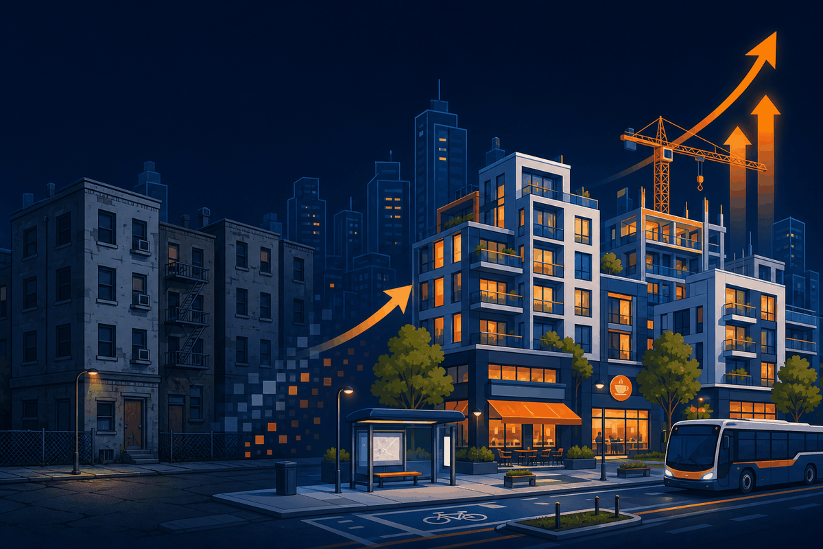
Reinvestment raising values; displacement risk for renters.
AP exam clue: New cafes plus rising rents in one paragraph.
Common mistake: Praising renewal without displacement harms.
Compare the four core U.S.-style models, then open each full guide for map clues and FRQ language.
| Model | Main Idea | Shape/Pattern | Best Clue | Common AP Mistake |
|---|---|---|---|---|
| Concentric Zone | Rings of land use by distance from CBD | Circular zones | Rings around core | Expecting perfect circles everywhere |
| Sector | Wedges along transport routes | Sector wedges | Corridors from CBD | Confusing with concentric rings |
| Multiple Nuclei | Several specialized centers | Scattered nodes | Airport, university, mall nodes | Forcing one monocentric CBD |
| Galactic / Peripheral | Edge cities on beltways | Suburban employment poles | Office parks on orbital highways | Calling all suburbs edge cities |
| Latin American | Elite spine and informal periphery | Spine + sector mix | Mansion zone plus squatter belts | Ignoring colonial core layering |
| Southeast Asian | Port-led export zones | Port + dense corridors | Factories along transit to port | Treating like U.S. sprawl only |
| African | Dual CBD and informal growth | Split cores + periphery | Colonial admin vs. market district | Single-center assumption |
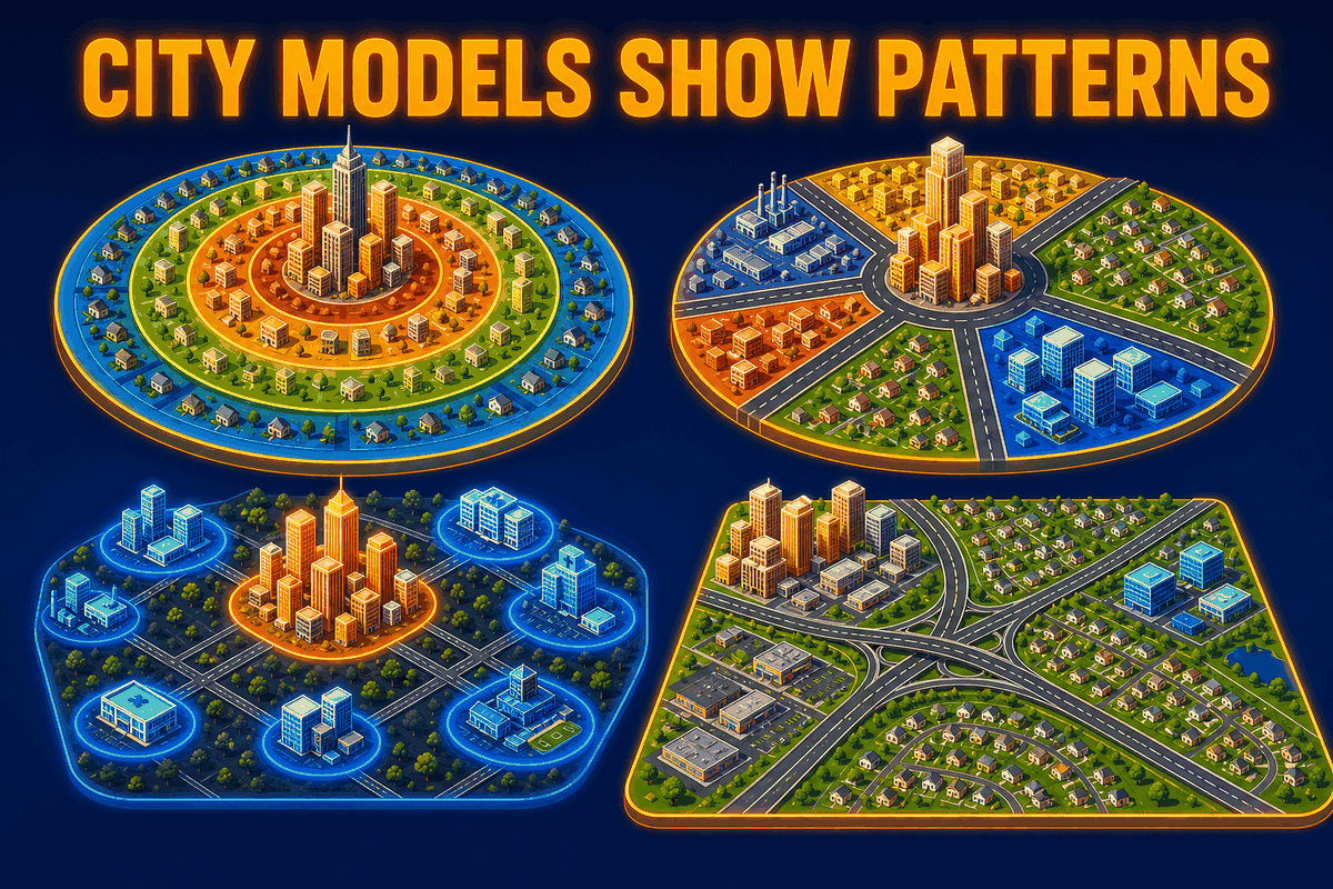
Open the urban land-use models study guide for side-by-side diagrams and practice.
Read each clue, reveal the answer, then open the full topic guide.
Answer: Concentric Zone Model
Why: Burgess’s model organizes land use in rings expanding outward from the central business district.
Answer: Sector Model
Why: Hoyt’s model shows housing and industry stretching in corridors along rails, roads, or rivers.
Answer: Multiple Nuclei Model
Why: Harris and Ullman argued cities develop multiple specialized centers instead of one core.
Answer: Galactic City Model
Why: Decentralized employment and retail on beltways fit automobile-oriented metropolitan sprawl.
Answer: World City
Why: World cities anchor multinational headquarters and advanced producer services—not size alone.
What is Central Place Theory?
Central Place Theory explains how settlements space themselves to provide goods and services to surrounding market areas. Higher-order functions need larger thresholds and wider ranges than everyday low-order goods like groceries.
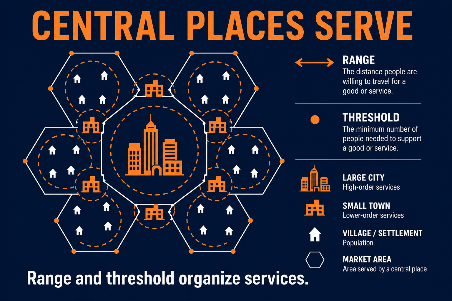
Study Central Place Theory in depth
Heart surgery hospital because it needs a larger threshold and range.
What is the difference between rank-size rule and primate city?
Rank-size describes a balanced urban system where the nth city is often about 1/n the size of the largest. A primate city pattern exists when one metro dominates—often more than twice the second city—in economy and culture.
Rank-size rule: In a balanced system, the nth city is often about 1/n the population of the largest—fourth city ≈ one-quarter of the largest.
Primate city: One metro dominates national economy and culture—often more than twice the second city (Paris, Buenos Aires, Bangkok examples on exams).
Simple example: Country A has cities of 8M, 4M, 2M, 1M (rank-size-like). Country B has 12M, 2M, 1.5M, 1M (primate).
AP exam clue: Population tables—compute ratios before you label primate vs rank-size.
What is the difference between a world city and a megacity?
A megacity is defined chiefly by very large population—often ten million or more. A world city is defined by command-and-control functions such as global finance, corporate headquarters, and advanced producer services.
World cities concentrate global finance, law, media, and corporate headquarters. Megacities and metacities are defined chiefly by population scale—often ten million people or more—with metacities describing fused metropolitan regions.
AP exam clue: Command functions signal world cities; headcount alone signals megacity.
What is urban sprawl?
Urban sprawl is low-density outward growth from a city, often shaped by highways, car dependence, and separated single-use zoning. It can lengthen commutes, raise infrastructure costs, and increase vehicle miles traveled.
Suburbanization and urban sprawl spread low-density housing and separated land uses along highways, raising commute times and infrastructure costs.
What is gentrification in AP Human Geography?
Gentrification is reinvestment and demographic change in a lower-income neighborhood as higher-income residents and businesses arrive, often raising property values and rents. Strong answers note improved services alongside displacement risk.
Gentrification brings reinvestment, new businesses, and rising property values while increasing displacement risk for long-term renters.
What are sustainable cities?
Sustainable cities use planning tools such as transit-oriented development, mixed use, density, green space, and growth boundaries to reduce pollution, congestion, and unequal environmental burdens while meeting housing needs.

AP clue: Look for finance/HQ language, not population alone.
AP clue: Compare largest to second city before you label.
AP clue: Name direction and density, not only “more people.”
AP clue: Balance benefits and harms in one answer.
AP clue: Transport lines are the sector giveaway.
AP clue: Daily milk vs. rare surgery hospital.
AP clue: Skyscrapers and bid rent signal CBD.
AP clue: Highway dependence and infrastructure cost.
Showing all 35 terms
Shift of population and economic activity toward cities.
Ranking settlements by size and service level.
Model of how settlements space services across a landscape.
Minimum demand needed to support a function.
Maximum distance consumers travel for a good or service.
Surrounding area served by a central place.
Regular size steps down the urban system.
Dominant city far larger than the second.
Global hub for advanced producer services.
Metro area over roughly ten million people.
Merged metropolitan complex exceeding megacity scale.
Central business district with peak land values.
Physical form and layout of a city.
Ring pattern expanding from the CBD.
Wedge-shaped zones along transport routes.
Several specialized activity nodes.
Edge cities on suburban beltways.
Residential area beyond the historic core.
Suburban employment and retail concentration.
Fast-growing large suburb.
Low-density fringe tied to a metro by long commutes.
Low-density, separated, outward expansion.
Reinvestment changing neighborhood class and rents.
Speculative panic selling for racial turnover.
Departure of white residents to suburbs.
Historic lending maps starving minority areas of credit.
Spatial sorting by race or income.
Deterioration of aging core neighborhoods.
Public or private renewal of urban districts.
Unauthorized housing on contested land.
Housing built outside formal regulation.
Walkable, mixed-use neighborhood design.
Compact, transit-friendly development policy.
Legal limit on outward urban expansion.
Fair distribution of environmental burdens and benefits.
Five sample MCQs with shuffled choices and explanations. Use FRQ strategy for free-response planning.
Central Place Theory
Central place theory predicts fewer cardiac surgery centers than corner stores mainly because hospitals need:
Correct: B. Higher-order services need more patients drawn from farther away—larger threshold and range.
Why not A: Smaller thresholds fit low-order daily goods like milk, not rare surgery.
AP clue: Match service type to threshold and range before you pick a settlement size.
Rank-size rule
In a balanced urban system, the fourth-largest city is often about what fraction of the largest?
Correct: C. Rank-size expects population of rank n ≈ largest ÷ n.
Why not A: 1/16 would imply an extremely steep drop not typical of rank-size balance.
AP clue: Compute largest ÷ rank before you label primate versus rank-size.
Primate city
Which scenario best illustrates a primate city?
Correct: A. Primacy shows overwhelming dominance of one metro over the rest.
Why not B: Similar regional capitals suggest a balanced ladder, not primacy.
AP clue: Compare the largest city to the second city before you name the pattern.
World city vs megacity
A world city is best defined by:
Correct: B. World/global cities anchor multinational HQ and advanced services—not size alone.
Why not A: Ten million people defines a megacity, not global command functions.
AP clue: Look for finance, headquarters, and producer services—not population alone.
City models
Ring-shaped zones expanding from a CBD describe which model?
Correct: B. Burgess concentric zones radiate outward from the core.
Why not A: Sectors are wedges along transport routes, not full rings.
AP clue: Rings around the CBD signal Burgess; wedges signal Hoyt.
Explain how highway expansion and separated-use zoning can contribute to urban sprawl in one metropolitan area. Use cause → pattern → consequence.
Compare your outline to the Unit 6 FRQ strategy section before you move on.
More AP HUG practice: daily practice, by course, by topic, and practice tests.
AP Human Geography Unit 6 studies how cities form, grow, organize land, connect to other places, and respond to urban problems. The unit focuses on urbanization, settlement hierarchy, city models, central place theory, rank-size rule, primate cities, suburbanization, sprawl, gentrification, and sustainable urban planning.
Expect Burgess concentric zones, Hoyt sectors, Harris–Ullman multiple nuclei, and galactic or peripheral sprawl patterns. Match each model to transport history and where housing, industry, and services concentrate.
Christaller-style central place theory explains how settlements space themselves to serve surrounding areas with goods and services. Threshold is minimum demand to keep a function profitable; range is how far people travel; higher-order functions need larger thresholds and wider ranges.
Rank-size describes a fairly regular urban system where the nth city is often about 1/n the size of the largest. A primate pattern exists when one metro dominates—often more than twice the second city—because power and services concentrate there.
A megacity is defined chiefly by very large population—often ten million or more. A world city is defined by command-and-control functions: finance, corporate headquarters, and advanced producer services.
Urban sprawl is low-density outward growth from a city, often shaped by highways, car dependence, single-use zoning, and suburban housing. It can increase commute times, infrastructure costs, farmland loss, and vehicle miles traveled.
Gentrification is reinvestment and demographic change in a lower-income neighborhood as higher-income residents and businesses arrive, often raising property values and rents. Balanced AP responses note improved services alongside displacement risk.
Sustainable cities use planning tools such as transit-oriented development, mixed use, density, green space, and growth boundaries to reduce pollution, congestion, and unequal environmental burdens while still meeting housing and economic needs.
Follow the Unit 6 learning journey on this hub, practice matching map clues to city models, drill threshold versus range, compare rank-size and primate city with real countries, and write short FRQs using cause → pattern → consequence.
Common prompts apply threshold and range, justify a city model from a description, explain gentrification tradeoffs, analyze sprawl drivers and sustainability responses, or interpret urban hierarchy from population tables.