Property boundaries
Survey systems define how farms, roads, and fields are legally separated on the landscape.
AP Exam Clue: Irregular lines suggest metes and bounds; grid lines suggest township and range.
Unit 5 Learning Journey · Agriculture and Rural Land Use
Land survey patterns show how land parcels are legally divided and organized across rural landscapes. In AP Human Geography, students use land survey patterns to explain property boundaries, farm shapes, roads, settlement patterns, historical colonization, and rural land-use organization.
The previous page, Rural Settlement Patterns, explained how homes, farms, roads, and villages are arranged across rural landscapes. This page explains how land is legally divided into parcels. Land survey patterns help students connect property boundaries, roads, farms, settlement layout, and historical settlement systems. After this page, students should study sustainable agriculture and Unit 5 practice questions.
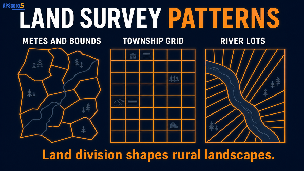
The land survey patterns AP Human Geography topic connects rural settlement layout to legal land division. When a prompt shows irregular boundaries, grid squares, or long narrow river lots, identify the survey system and explain how it shaped farms, roads, and rural land use.
Settlement layout shows how people arrange homes and farms.
Land Survey Patterns
Parcel division explains property lines and farm shapes.
Land survey patterns are systems used to divide land into property parcels. In AP Human Geography, the three major land survey patterns are metes and bounds, township and range, and long lot. These patterns help explain rural landscapes, property boundaries, farm shapes, road networks, settlement history, and how people organize land for agriculture.
AP prompts often show one parcel layout on a map. Your job is to name the survey system and explain what it suggests about rural land use. Compare with rural settlement patterns when both property lines and home layout appear.
| Survey Pattern | What It Looks Like | Why It Formed | AP Exam Clue |
|---|---|---|---|
| Metes and bounds | Irregular parcel shapes | Boundaries follow landmarks, trees, streams, or local features | Uneven, non-grid property lines |
| Township and range | Rectangular grid | Land divided systematically into townships and sections | Square parcels, straight roads, grid pattern |
| Long lot | Long narrow parcels | Many farms need access to a river, road, or canal | Thin strips stretching away from water or road |
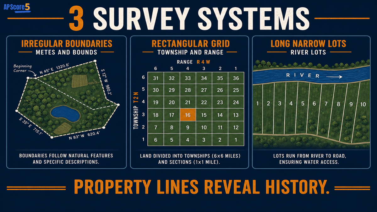
Land survey systems explain why some rural areas show irregular farm boundaries, repeated square parcels, or long narrow strips along rivers and roads.
On AP Human Geography questions, land survey patterns usually appear as visual clues. Start with the shape of the parcels, then explain why that shape exists.
| Map Clue | Likely Survey Pattern | Why It Matters |
|---|---|---|
| Irregular property lines | Metes and bounds | Boundaries may follow natural features or older local landmarks |
| Repeated square or rectangular parcels | Township and range | Land was divided through a systematic grid |
| Long narrow strips along a river | Long lot | Each parcel gets water or transportation access |
| Straight rural roads in a grid | Township and range | Roads often follow parcel boundaries |
| Uneven farms with curved boundaries | Metes and bounds | Landscape features may shape property lines |
| Narrow lots extending back from a road | Long lot | Access is shared along a transport route |
Land survey patterns and rural settlement patterns are connected, but they are not the same. Survey patterns describe how land parcels are divided. Settlement patterns describe how homes, farms, roads, and villages are arranged.
| Concept | What It Describes | AP Clue |
|---|---|---|
| Land survey pattern | How land parcels are legally divided | Grid, irregular parcels, long narrow lots |
| Rural settlement pattern | How homes, farms, roads, and villages are arranged | Clustered, dispersed, linear |
| Farm type | What is produced or how farming works | Dairy, grain, ranching, plantation |
| Agricultural land use | How land is used for farming | Crops, livestock, settlement, roads |
Land survey patterns do not appear randomly. Property boundaries, roads, farm shape, settlement layout, history, water access, and transportation routes all connect to how land was divided.
Survey systems define how farms, roads, and fields are legally separated on the landscape.
Roads often follow property boundaries, so a grid survey can produce straight roads while irregular parcels may produce less regular road networks.
Parcel division influences whether farms appear as squares, irregular polygons, or long narrow strips.
How land is divided can encourage clustered villages, dispersed farmsteads, or linear settlement along transport routes.
Colonial surveys, French long lots, and the U.S. Public Land Survey System left lasting rural property patterns.
Long lot systems often give many farms riverfront access while extending fields away from the water.
Roads, canals, and rivers can organize how parcels are drawn so landowners share access.
Regular grids can organize commercial grain farming, while irregular parcels may reflect mixed local landholdings.
These factors overlap with Von Thünen model thinking when market access and transport costs influence where farming households locate relative to cities and routes.
Use this table when an AP question asks you to compare survey systems or explain map evidence for each parcel type.
| Feature | Metes and Bounds | Township and Range | Long Lot |
|---|---|---|---|
| Basic shape | Irregular parcels | Rectangular grid | Long narrow strips |
| Boundary basis | Landmarks, direction, distance | Townships, sections, grid lines | River, road, canal, or transport access |
| Common map clue | Uneven boundaries | Repeated squares or rectangles | Thin parcels beside water or road |
| Historical association | Older eastern U.S. settlement patterns | U.S. Public Land Survey System | French-influenced settlement areas and river access |
| AP mistake | Calling every irregular parcel random | Forgetting it is a systematic grid | Forgetting the access function |
A rural map with irregular property boundaries may show metes and bounds.
A map with repeated square farm parcels may show township and range.
Long narrow farms along a river may show the long lot system.
Straight roads and rectangular farms often reflect township and range.
Uneven property lines can reflect natural landmarks or older local surveys.
Narrow parcels along a road can provide equal access to transportation.
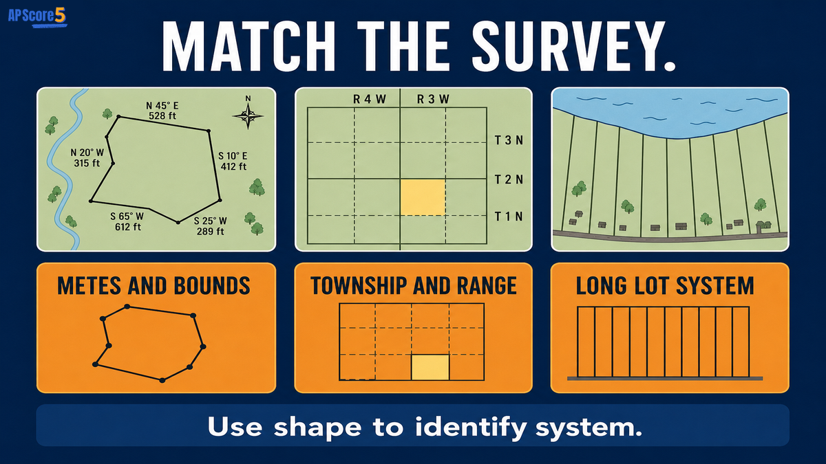
Use this four-step method on MCQs and FRQs when a prompt describes irregular parcels, grid farms, or long narrow lots.
Name irregular, grid, or long narrow from map evidence.
Match metes and bounds, township and range, or long lot.
Point to property lines, roads, rivers, or parcel width.
Connect division to settlement, access, roads, or farm organization.
The land survey pattern is __________ because the map shows __________. This pattern likely shaped rural land use by __________.
Example: The land survey pattern is long lot because the map shows long narrow parcels extending from a river. This pattern likely shaped rural land use by giving many farms access to water and transportation.
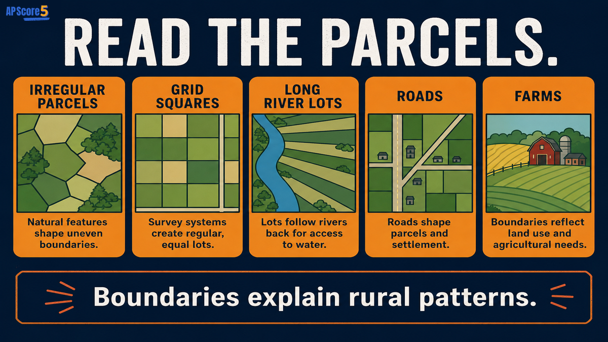
One Perfect AP Sentence: A land survey pattern shows how property boundaries divide rural land, and the parcel shape can reveal historical settlement, access to transportation or water, and the organization of farms and roads.
Use this sentence when an FRQ asks you to explain how rural landscapes reveal land division.
| Concept | Main Meaning | AP Clue |
|---|---|---|
| Land survey pattern | How property parcels are divided | Metes and bounds, township and range, long lot |
| Rural settlement pattern | How homes and farms are arranged | Clustered, dispersed, linear |
| Farm type | What is produced or how farming works | Dairy, grain, ranching, plantation |
Confusing township and range with clustered settlement
Calling long lot a linear settlement without explaining parcel shape
Identifying a grid but not naming township and range
Forgetting that metes and bounds can create irregular boundaries
Saying long lot is random when it gives access to water or roads
Describing the map but not explaining the land-use effect
Read each scenario, predict the survey pattern, then reveal the answer. This trains the same reasoning AP Human Geography uses on rural land-use map prompts.
Revealed: 0 of 4 scenarios
A rural map shows irregular farm boundaries that follow streams, old roads, and local landmarks. Which land survey pattern is shown?
Answer: Metes and bounds, because boundaries are irregular and may follow natural features, landmarks, directions, and distances.
A map shows repeated square parcels and straight roads in a grid. Which land survey pattern is shown?
Answer: Township and range, because the land is divided into a regular rectangular grid.
A settlement has long narrow farms extending back from a river. Which land survey pattern is shown?
Answer: Long lot, because parcels are long and narrow so each farm can access the river.
A road runs through farmland, and narrow properties extend back from the road. Which land survey idea is shown?
Answer: Long lot logic, because narrow parcels can provide many landowners access to a transportation route.
Answer all eight questions. Choices shuffle each time you reload, so focus on reasoning—not letter memorization.
Open each card, draft your response, then reveal the rubric and sample when ready. Strong land survey FRQs identify the pattern, cite parcel evidence, explain why it developed, and connect the layout to rural land use.
A rural landscape map shows repeated square farm parcels and straight roads forming a grid. Identify the land survey pattern and explain one way it shapes rural land use.
The land survey pattern is township and range because the map shows repeated square farm parcels and straight roads forming a grid. This pattern shapes rural land use by creating regular property boundaries and a predictable road network. The grid can organize farms into rectangular parcels and make rural transportation and land ownership easier to map.
Status: Draft your answer first—then open the rubric or sample.
A map shows long narrow farms extending from a river. Identify the land survey pattern and explain why this pattern may have developed.
The land survey pattern is long lot because the map shows long narrow farms extending from a river. This pattern may have developed so many farms could have access to water, transportation, or fertile riverfront land. The narrow parcels allow households to use the river while farming land that stretches away from it.
Status: Draft your answer first—then open the rubric or sample.
Land survey patterns are systems used to divide land into property parcels. They help explain property boundaries, farm shapes, roads, and rural landscape organization.
The three main land survey patterns are metes and bounds, township and range, and long lot.
Metes and bounds is a land survey system that describes boundaries using natural features, landmarks, directions, and distances, often creating irregular parcel shapes.
Township and range is a rectangular survey system that divides land into a grid of townships and sections, often producing square or rectangular parcels.
The long lot survey system divides land into long narrow parcels, often extending back from a river, road, or canal so many farms have access to transportation or water.
Land survey patterns describe how land parcels are divided, while rural settlement patterns describe how homes, farms, roads, and villages are arranged.
They matter because parcel shapes can reveal historical settlement, land ownership, transportation access, road layout, and agricultural organization.
Identify the survey pattern, cite parcel-shape evidence, and explain how it affects rural land use, settlement, transportation, or property boundaries.